By Thiago Luiz Ticchetti, 1 June 2015
(Revista UFO (Brazilian UFO Magazine), Campo Grande, Brazil)
The UFO incident occurred over Quixadá, Ceará, Brazil,
on
24 January 2014, at 12:10 p.m., according to the
article.
COMDABRA is the acronym for Comando de Defesa Aeroespacial
Brasileiro (Brazilian Aerospace Defense Command).
COMDABRA is responsible for receiving and cataloging
the
occurrences of UFO incidents, according to the
official (Brazilian
Air Force) decree, named Portaria (Ordinance) 551/GC3
(dated
9 August 2010), Brazilian UFO researcher A. J. Gevaerd
reported
English translation (by Google Translate):
Reverso Context search results: COMDABRA:
Wikipedia article: “Departamento de Controle do Espaço
Aéreo”:
English translation of the Wikipedia article:
“Department of Airspace Control”:
“The Department of Airspace Control ( DECEA ) is a
military governmental entity of the Brazilian Air Force Command, which in turn
reports to the Ministry of Defense. Its mission is to manage the operation of
traffic services in Brazil's
sovereign airspace, as well as to coordinate their defense with COMDABRA (
Aerospace Defense Command ).
…
Brazilian Airspace
Responsible flight information regions of Brazil.
The airspace under the responsibility of the country
extends beyond its borders. It surpasses the area over its territory and
reaches a significant part of the Atlantic Ocean,
making a total of 22 million km2, on land and sea, agreed in international
treaties.
In other words, in Brazil, air control assumes
gigantic proportions, which makes it a strategic and national security task,
entrusted by law to one of the Armed Forces.
The Department of Airspace Control (DECEA) is the
organization of the Air Force Command responsible for controlling this area. It
brings together human resources, equipment, accessories and infrastructure with
the mission of providing the safety and fluidity of the region's flights.
Thus, the evolution of air traffic flow in the
national airspace is controlled daily by four major operational bases,
subordinate to DECEA: the integrated air defense and air traffic control
centers, also known as CINDACTA.
They act on airspace subdivisions called Flight
Information Region, or FIR, according to official nomenclature. In Brazil, there
are five FIRs, on which four CINDACTAs operate:
CINDACTA I (Brasília-DF) Responsible for the Brasília
FIR, which covers the central region of Brazil.
CINDACTA II (Curitiba-PR) Responsible for the Curitiba
FIR, which covers the south and part of south-central Brazil.
CINDACTA III (Recife-PE) Responsible for the Recife and Atlantic FIR,
covering the Northeast and the Atlantic Area
CINDACTA IV (Manaus-AM) Responsible for the Manaus
FIR, which extends over much of the Amazon region.
At the same time, CINDACTAs bring together civil air
traffic control and military air defense operations. A successful integration
solution that has been recommended by the International Civil Aviation
Organization (UN activity regulator) to the other signatory countries, as a
model of economy of means and operational safety.
The Cindactas are also added by the São Paulo Regional
Flight Protection Service (SRPV-SP), which is responsible for controlling the
highest flow density traffic in the country, along the São
Paulo and Rio de Janeiro
air terminals.
Finally, to ensure a balance between capacity and
demand at aerodromes and control sectors, there is yet another DECEA unit, the
Air Navigation Management Center (CGNA).
Created from the necessity of air flow ordering in
order to speed it up where there is opportunity or need, the CGNA operates
under a collaborative decision logic, in which representatives of airlines,
airport administrators, regulatory organizations, among others, are
participants. and they are exposing information daily and sharing
responsibilities in order to join forces in the name of more effective
decisions.
The CGNA is a kind of operational manager of the
country's flight flows, where all air movements are monitored 24 hours a day,
in order to enable air circulation, ensuring the effectiveness and operational
safety of air transport.”
Wikipedia article: “CINDACTA”:
Related posts:
(A. J. Gevaerd Posts Regarding the New Brazilian
Government (Air Force) UFO Decree)
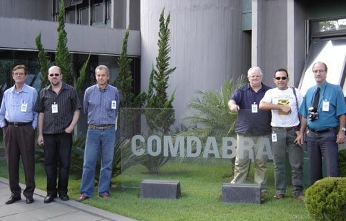
Brazilian
ufologists visited COMDABRA (the Brazilian Aerospace Defense Command) in Brasilia on 20 May 2005
(From left to right: Roberto Beck, Rafael Cury,
Marco Petit,
A. J. Gevaerd, Fernando Ramalho and Claudeir
Covo)
(rense.com photo)
Satellite photo of Quixadá, Brazil
(tageo.com)
(tageo.com photo)